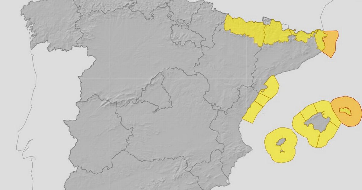
Amber and yellow warnings are in force for Menorca, Mallorca and Empordà
Weather warnings have been issued for a number of popular Spanish holiday destinations including Menorca, Aragón, Illes Balears and Cataluña. Amber warnings are in place for later this week in Menorca and Empordà.
Aemet, Spain’s national weather agency, has issued amber and yellow warnings across the eastern side of the country for Tuesday, November 25 and Wednesday, November 26.
On Wednesday, Menorca is listed as an important risk, with northern winds of between 50 and 75 km/h and waves of 4 to 6 meters with a maximum wave of 10 to 12 meters.
Empordà is also listed as an important risk, with northern winds of 60 to 80 km/h and waves of 4 to 5 m with a maximum wave of 6 to 8 m.
Mallorca is listed with a risk level of 40%-70% on Wednesday, with north and northwest winds of 50 to 60 km/h and waves of 3 meters.
The general forecast for Wednesday on Aemet reads: “Significant snow accumulations are likely in the Pyrenees during the early hours. Strong northerly winds with very strong gusts are expected in the lower Ebro region, the Pyrenees, the Empordà region, and the Balearic Islands.
“The arrival of high pressure from the west will bring stable weather to the Iberian Peninsula, with mostly clear or partly cloudy skies in the southern and northeastern half, and cloudy or overcast skies elsewhere, tending to clear in the northern plateau and the Iberian System. Light precipitation is expected in the Cantabrian area, the upper Ebro Valley, and northern Galicia, the Iberian System, and the Pyrenees, also possible in the central mountains and Melilla, with a tendency to diminish.
“Snowfall is expected at elevations of 1000-1300 meters; 600-800 meters in the Pyrenees, where significant accumulations are likely in the early hours. Unstable conditions are expected in the Balearic Islands, with cloudy skies and showers, becoming heavier with thunderstorms and possible hail in Menorca and Mallorca, where they could be locally heavy.
“In the Canary Islands, cloudy skies with light rain in the north of the mountainous islands and cloudy intervals in the rest with a possibility of some light and occasional rain. Morning fog banks in the mountains of the northern half of the Iberian Peninsula, also possible in the northern plateau and Galicia. Maximum temperatures decreasing in the eastern half of the peninsula, the archipelagos, and Melilla, with little change elsewhere.
“Minimum temperatures decreasing except in the northwestern third of the peninsula, where little change is expected. Light frosts are expected in mountainous areas of the northern and southeastern half of the peninsula, the northern plateau, and the northeastern part of the southern plateau; moderate to locally severe frosts are possible in the Pyrenees.
“Northern winds will prevail in the Peninsula and the Balearic Islands, with westerly winds in the Alboran Sea becoming variable and westerly winds settling in the Cantabrian Sea. Winds will be moderate in the eastern third of the peninsula, the eastern Cantabrian coast, the Balearic Islands, and the Gulf of Cádiz, and strong winds with very strong gusts are expected in the lower Ebro Valley, the Pyrenees, the Empordà region, and the Balearic Islands, possibly affecting other coastal areas of the eastern peninsula. Moderate trade winds in the Canary Islands.”