We want to make sure you’re prepared for winter weather across the state of Texas and in the Houston area.
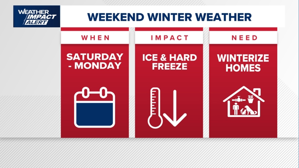
HOUSTON — Confidence is increasing that those of us in southeast Texas could see significant winter weather impacts this weekend and into early next week. Because forecast models continue to align, the KHOU 11 Weather Team has a Weather Impact Alert in effect for Saturday, Sunday, and Monday.
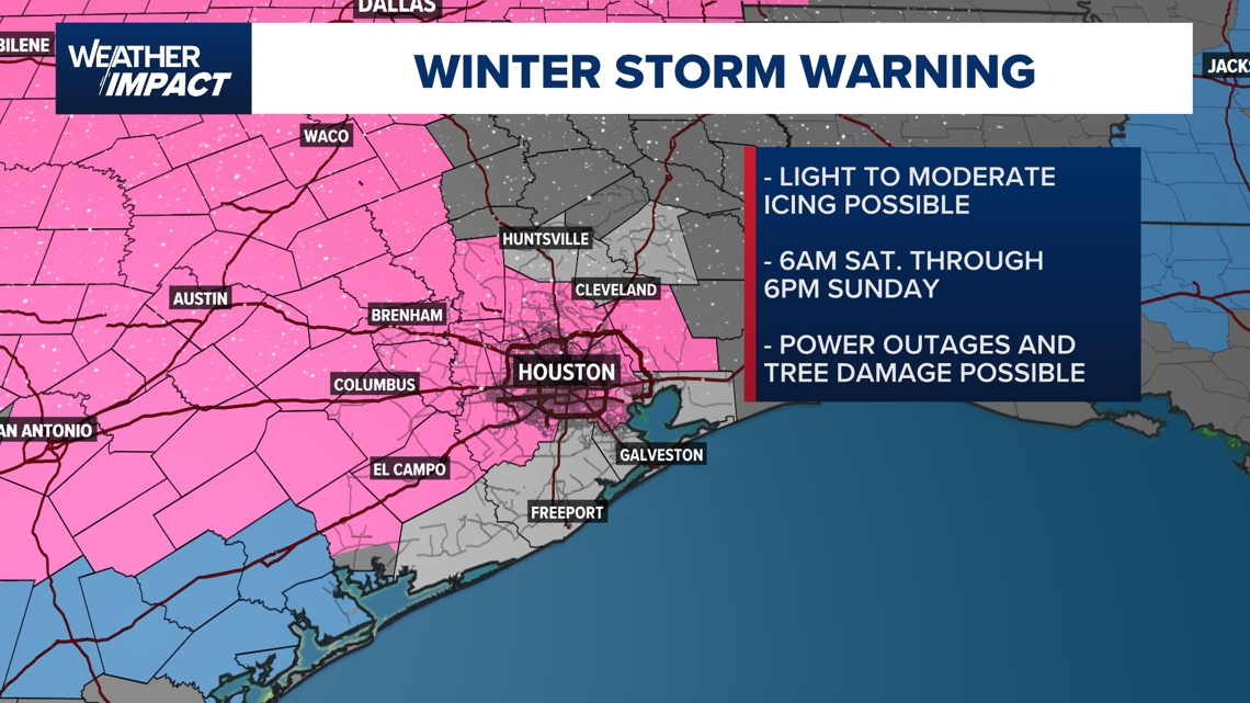
- A Winter Storm Warning will be in effect for Harris and surrounding counties Saturday and Sunday. This includes the immediate Houston area.
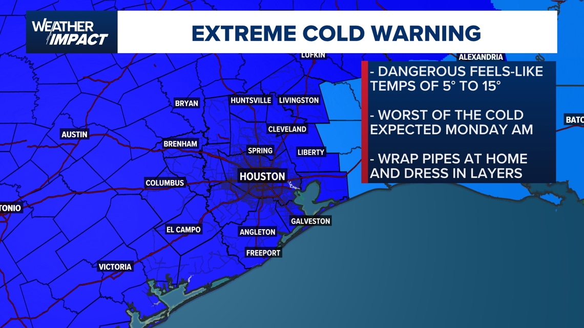
- An Extreme Cold Warning will be in effect this weekend all across the Houston area. The coldest temperatures are expected Monday morning.
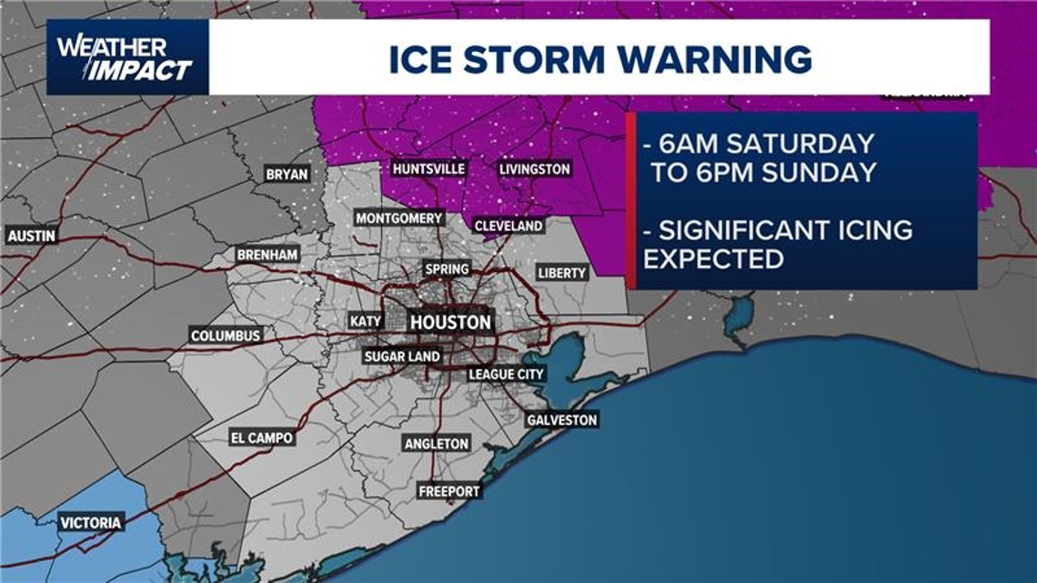
- An Ice Storm Warning will be in effect for Madisonville, Trinity, Coldspring, Shepherd, Groveton, Corrigan, Livingston, Huntsville and Crockett from 6 p.m. Saturday through 6 a.m. Sunday.
Throughout our winter weather, KHOU 11 will be with you, on TV, on our mobile app, and on KHOU 11+.
Forecasters are closely monitoring the setup that could bring freezing rain, ice, dangerously cold temperatures, and hazardous travel conditions to the Houston area. We have a detailed timeline below on this page with what to expect day by day.
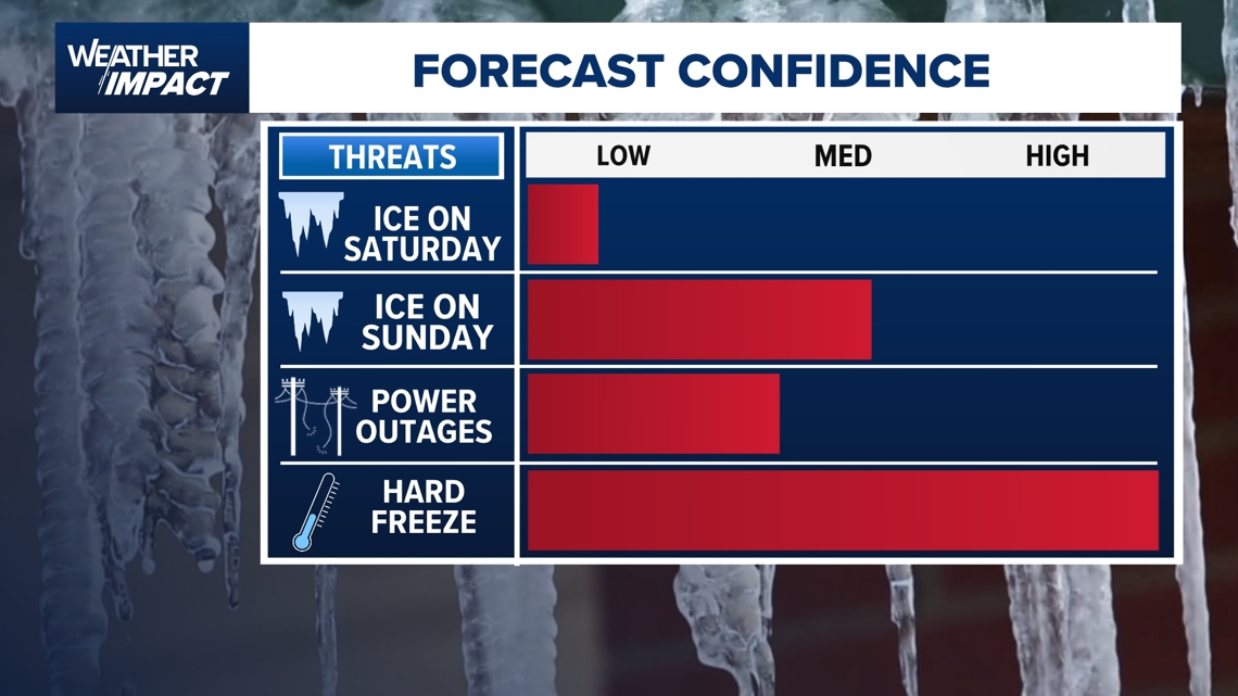
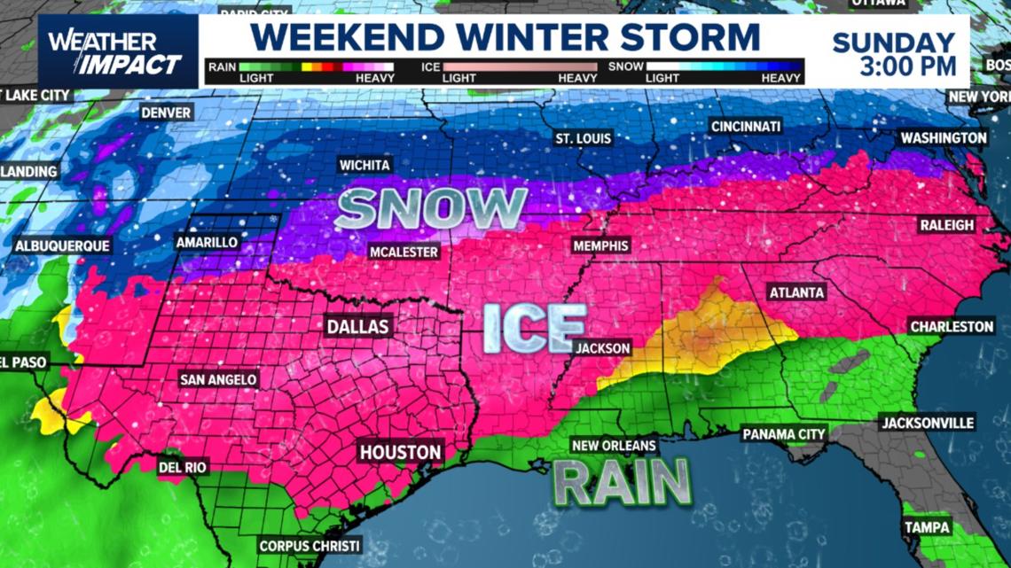
Houston area winter weather forecast confidence
When meteorologists talk about “forecast confidence,” they’re referring to how likely it is that conditions will develop as expected. That confidence is increasing for winter weather impacts beginning Saturday night and lasting into Monday morning.

Detailed timeline for Houston area winter weather
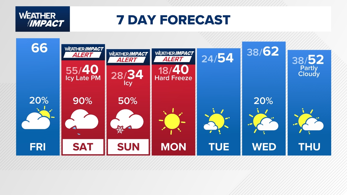
Saturday: A cold rain and the final window to prepare
Saturday begins as a transition day — not dangerous yet, but clearly changing. Temperatures start the morning in the 50s, and while they will steadily fall, much of the day remains above 40 degrees. That keeps precipitation firmly in the form of rain for most people. Meteorologist Chita Craft describes Saturday as manageable: a cold, steady rain, but not a washout and not yet icy.
Rain is expected to be widespread by early morning, as early as 6 or 7 a.m., and it continues through the day. This is still considered a safe window to run errands, make final preparations at home, or keep plans like lunch or appointments. Cloud cover keeps temperatures fairly uniform, with readings dropping from the 50s into the 40s and eventually the upper 30s by late evening.
The bigger change begins late Saturday night. As Arctic air pushes in quickly, temperatures fall toward and then below freezing. Rain may begin transitioning to freezing rain late Saturday evening, particularly in northern parts of the region. Areas north of Harris County — including Walker County and points north — may see that transition earlier. For much of Harris and Fort Bend counties, the shift toward freezing conditions mainly happens overnight.
By around 7 p.m. Saturday night, Chita says drivers should strongly consider staying put. That’s when conditions begin deteriorating ahead of what’s expected to be the most dangerous stretch of the forecast.
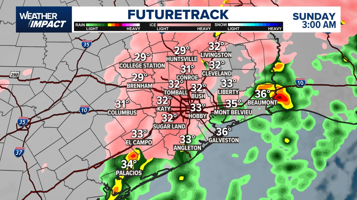
Sunday: Freezing rain, ice, and a day to stay indoors
Early Sunday morning marks the true impact. Temperatures drop into the upper 20s and Low 30s by Sunday morning.
This is the point in the forecast when people should hunker down. Roads are expected to be dangerous, and even confident drivers are warned not to chance it. The presence of ice — even in small amounts — can make travel treacherous.
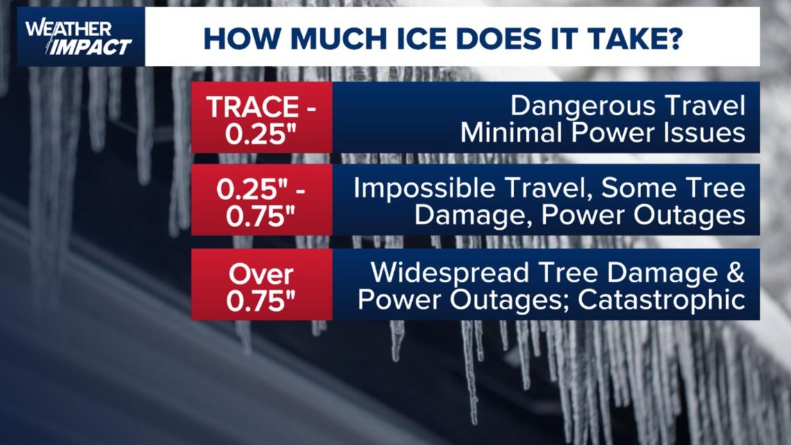
Ice accumulation is possible across the region, with much of the area expected to stay under a quarter inch. Even so, Chita explains that just a trace to around a tenth of an inch can still make roads dangerous. Areas north of the Houston metro see ice totals increase quickly, which is why statewide travel becomes especially difficult.
Sunday is not a day for errands or outings. The advice –stay indoors, avoid travel, and prepare for impacts tied to both ice and bitter cold.

Monday: Deep freeze and lingering impacts
Conditions remain dangerous into Monday, with temperatures falling even further. Monday morning lows are forecast near 22 degrees, putting the region deep into a hard freeze. Any ice that formed Sunday is slow to melt, and freezing rain or icy conditions may persist.
Ice accumulation remains a key concern. While most of the Houston area is expected to stay below crippling thresholds, amounts approaching a quarter inch could still lead to problems, including possible power outages. Areas just north of the region will see much higher totals.
Monday is still considered part of the “stay put” period. Travel remains unsafe and conditions won’t improve quickly due to how cold it stays. The hope is for a best-case scenario with limited ice and minimal power disruptions, but the risk remains as long as temperatures stay in the 20s.

Winter Storms Warning for Houston area
The National Weather Service has issued a Winter Storm WARNING for the Houston area from Saturday morning through Sunday afternoon, citing the potential for heavy mixed precipitation and ice accumulation. These conditions could lead to dangerous travel, downed trees, and power outages.

Extreme Cold Warning for Houston area
An Extreme Cold Warning is also in effect from Saturday night through Monday morning, with wind chills as low as 5 to 15 degrees possible. The coldest temperatures are expected Sunday night into Monday morning, and a hard freeze is possible both Saturday night and Sunday night.


Ice Storm Warning for Southeast Texas
An Ice Storm Warning has been issued for parts of the Houston area, including Trinity, Polk, Madison, Walker, and San Jacinto counties from 6 p.m. Saturday to 6 p.m. Sunday.

How much ice does it take to knock out power?
As confidence grows in a significant winter weather event across Southeast Texas, one of the biggest concerns is ice.
Freezing rain can quietly accumulate on roads, trees, and power lines, adding weight that infrastructure isn’t built to handle in this part of Texas.

What the models are showing
Forecast models show areas across Texas where rain could transition into ice, including freezing rain and sleet — conditions known for rapid ice buildup.
The European model currently suggests a slightly less aggressive scenario for Houston, while the American (GFS) model pushes ice potential farther south. Meteorologists caution against focusing on exact accumulation numbers, noting that even light ice can cause major problems, especially if heavier icing north of the region disrupts power transmission.

Houston forecast