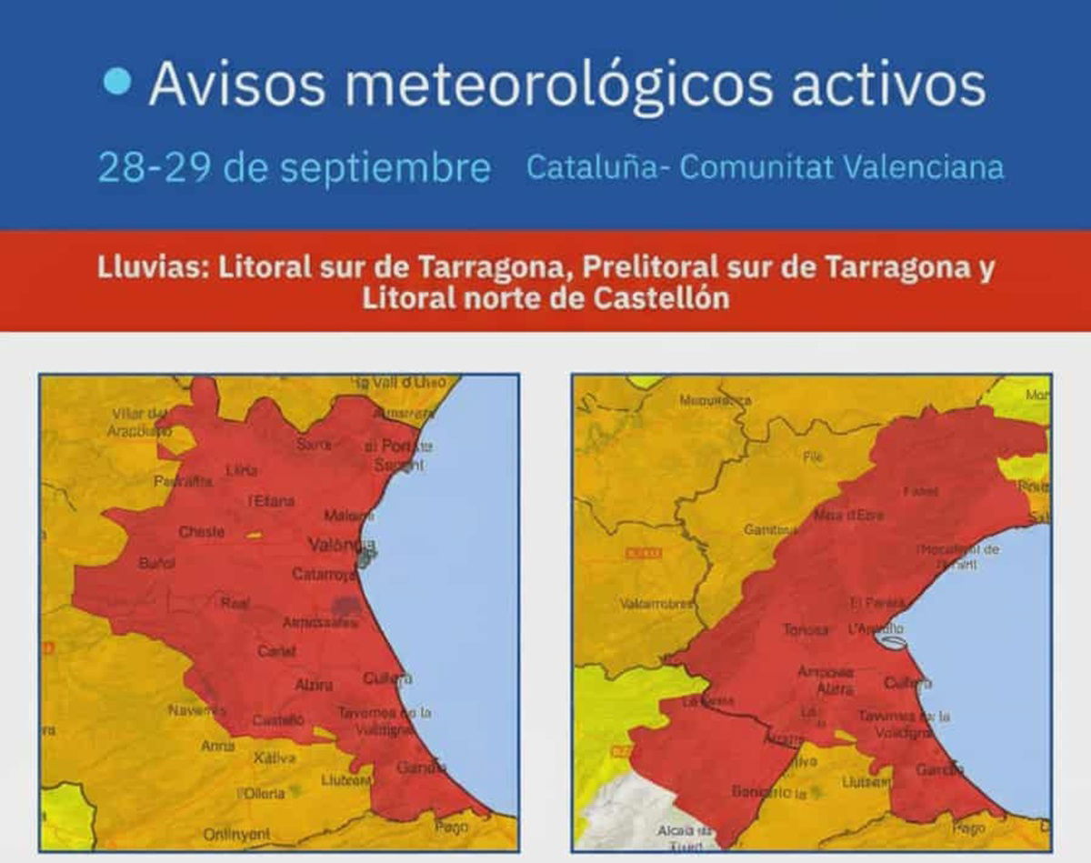
Aemet map highlighting red alert zones in Valencia, Castellón and Tarragona.
Credit : X – AEMET_Esp
Spain is bracing itself for another battering from the skies, with the national weather service Aemet raising its warning level to red – the highest possible – for parts of Valencia, Castellón, Tarragona and Lleida.
Residents have been told to stay alert, stay indoors if possible, and prepare for what could be a dangerous start to the week.
Red alert issued as ex-hurricane fuels storm
What began as an orange warning on Sunday morning quickly escalated by the afternoon, when forecasters confirmed that a new DANA system (isolated depression at high levels), fuelled by the remnants of ex-hurricane Gabrielle, was heading straight for eastern Spain.
According to Aemet, conditions are expected to be “potentially dangerous between Sunday evening, September 28 and Tuesday September 30”, with the worst of the downpours set to hit overnight and into Monday morning.
The timing has made nerves run even higher: the storm arrives just 11 months after the floods that killed 229 people across Valencia and left entire communities devastated.
Torrential rain set to pound the east coast
From 8pm Sunday, September 28, red alert measures are in force for northern Castellón, and from 4am Monday, September 29, the Valencian coastline will be under the same level of risk. Heavy, sudden downpours are expected to lash much of the region, with Tarragona and Lleida also forecast to see extreme rainfall.
Meteorologists warn of up to 120 litres per square metre in just three or four hours in some areas – more than enough to cause flash floods, landslides and dangerous road conditions. In Lleida, rain could reach 40 litres per square metre in just one hour, while parts of Tarragona may see 80 litres in an hour during the peak of the storm.
Local authorities have already suspended classes in several towns and cities, while emergency teams have been placed on standby. Residents are being urged to stock up on essentials, avoid unnecessary travel, and above all, steer clear of flood-prone areas.
‘Maximum caution’ urged by officials
The secretary for Emergencies, Irene Rodríguez, has called for all administrations to act early and make sure safety measures are in place. “We are facing an episode of important rainfall across the region. Everyone needs to be aware and prepared,” she said.
In Catalonia, regional president Salvador Illa made a direct appeal on social media, asking citizens to exercise ‘maximum caution’, avoid risky journeys, and stay away from rivers, underground car parks, tunnels, and low-lying roads. Civil Protection has repeated the warning, stressing that even short trips could become hazardous if floodwaters rise.
The sense of unease is amplified by the recent past. Last year’s floods are still fresh in people’s minds, and with emergency sirens already sounding across some towns, the memories of devastation remain raw.
What’s next for Spain’s weather warnings
While forecasters expect the storm to ease by midweek, the next 48 hours are likely to bring severe disruption across the east of Spain. From transport delays to school closures and possible power outages, daily life is set to be heavily affected.
For now, the advice is clear: stay indoors wherever possible, follow official updates, and don’t underestimate the power of sudden floods. As Aemet put it, the coming hours will be ‘potentially dangerous’ – and with the alert now set to red, there is no higher warning.
Spain will be holding its breath until the skies finally clear.